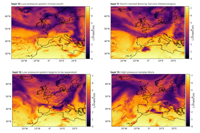
In a new weekly update for pv magazineSolcast, a DNV company, reports that as Storm Boris raged across Europe, snow began to fall in some regions for the first time this season. The situation is stabilizing as the system weakens and an area of high pressure establishes itself across the region.
Storm Boris has brought a mix of extreme weather to Europe, ranging from heavy rainfall and flooding to the first snow of autumn, according to an analysis using the Solcast API. This low-pressure system, dubbed Boris by Italy’s Servizio Meteorologico, unleashed record-breaking rain across central Europe, while Britain and parts of the Alps saw their first snow. The situation is stabilizing as the system weakens and an area of high pressure establishes itself across the region.
Central Europe suffered severe flooding as Storm Boris brought record-breaking rainfall levels, with some regions experiencing unprecedented rainfall totals. The convergence of cold Arctic air with warmer air masses in the Mediterranean and Caspian Seas resulted in
persistent rain and snow across the region. Part of the low-pressure system became trapped over the Adriatic Sea, forming a slow-moving secondary system that continued to rain, leading to several days of downpours. In some areas, months of rain fell in just a few months
a few days, overwhelming local infrastructure and triggering severe weather warnings in several countries.
As the storm swept through Europe, snow fell in some regions for the first time this season. In Britain, Arctic winds dropped temperatures enough that the peaks of Scotland saw snow for the first time since the summer. The Italian and Austrian Alpine regions also saw early snowfall, especially at higher elevations, where rain from Storm Boris turned into heavy snowdrifts.
Conditions are currently less intense across Europe as Storm Boris heads south-eastern Italy. The system has weakened since crossing into Italy, but continues to cause flooding and rapid evacuations. Forecasts show a brief revival of rain in the coming days, before more rain falls in central Europe next week.
Solcast produces these figures by tracking clouds and aerosols worldwide at a resolution of 1-2 km, using proprietary satellite data AI/ML algorithms. This data is used to drive irradiance models, allowing Solcast to calculate high-resolution irradiance, with a typical deviation of less than 2%, as well as cloud tracking predictions. This data is used by more than 300 companies that manage more than 150 GW of solar energy worldwide.
The views and opinions expressed in this article are those of the author and do not necessarily reflect those of the author pv magazine.
This content is copyrighted and may not be reused. If you would like to collaborate with us and reuse some of our content, please contact: editors@pv-magazine.com.
Popular content


